Objective: Shifting the coordinates on the
surface of the rotational ellipsoid
Description:
Classic
problem of calculating the coordinates on the surface of the ellipsoid of
rotation, and azimuth and length of line is called the geodetic coordinates of
the transfer. There are two types of problem: the so-called. Direct shifting
and reverse
shifting.
Task 1 -
(direct shifting) consists in calculating the geodetic coordinates B2 L2 P2 and
the geodetic azimuth line when the data are the coordinates of point P1 B1, L1,
the length of the geodesic s and azimuth A of the geodesic line which starts
from the point of P.
Task 2 -
(reverse shifting) refers to the calculation of the length of the geodesic
connecting the surface are ellipsoids two points with known coordinates of P1
and P2 and the calculation of the geodetic azimuth lines (straight and vice
versa)
Example
calculation method:
Among
the several methods of calculation will be presented method of the average
width of the Gaussian-task directly (Fig. 1.) Ranking calculations performed
according to an algorithm (Fig.2.), Where B=j, L=l by the signs of surveying. Calculate the coordinates of the transfer
must be made with the established minimum accuracy (table 1). This condition requires an iterative calculations.
Suppose that in this example the condition is met in the second approximately.
Tab.1. Precision requirements:
|
•30-100
km: coordinates ±0.0001”, azimuth ±0.001” |
|
•Do 1000
km: coordinates ±0.001”, azimuth ±0.01” |
|
•Do 20
000 km: coordinates ±0.003”, azimuth ±0.03” |
•
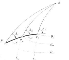
Fig.1.
The
method of the average latitude of the Gaussian
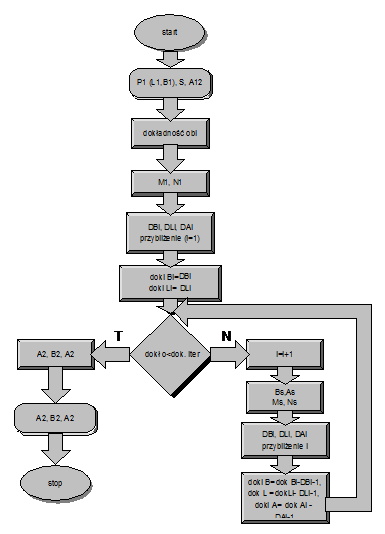
Fig.2. Algorithm
Formulas as
follow:
![]()
![]()
![]()
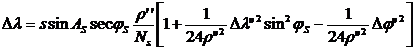
First iteration as follow
![]() , where
, where ![]()
![]() , where
, where 
![]()
where:
r”=206264.8062 – radian expressed in seconds
t2=tg2js
![]()
![]()
![]()
![]()
Second iteration as follow
![]()
![]()
Example:
Ellipsoid WGS-84
|
A |
6378137 |
|
e2 |
0.006694438 |
|
e’2 |
0.0673949674227 |
Initial
data
![]()
![]()
A=315o
S=200000
Result
![]()
![]()
A2=134.41o